• Skip to primary navigation
  • Skip to main content
  • Skip to footer

SC Picture Project

The purpose of the South Carolina Picture Project is to celebrate the beauty of the Palmetto State while preserving some of its vanishing landscapes.

  • FIND A LANDMARK
    • BY CITY
    • BY COUNTY
    • BY CATEGORY
    • BYGONE LANDMARKS
  • ADD IMAGES
  • VOLUNTEER
  • SPONSORS
  • DONATE

Santee State Park

SC PICTURE PROJECT Leave a Comment

SC Picture Project / Orangeburg County / Santee State Park

Santee State Park on Lake Marion is a 2,500-acre park founded in 1942. It was established on land in Santee donated by Orangeburg County for public use. While the Palmetto State’s largest lake is the park’s most alluring feature, other park amenities include three nature trails, birding opportunities, tennis courts, and a seven-and-a-half-mile-long biking trail. However, most people come to the park for its prime views and easy access to Lake Marion.

Santee State Park Boardwalk

Jim Dollar of Indian Land, 2014 © Do Not Use Without Written Consent

While there is no designated swimming area at Santee State Park, swimming is allowed at your own risk. Two boat ramps offer access to the lake, and a fishing pier, seen above, allows for a day of wetting a hook without leaving dry land.
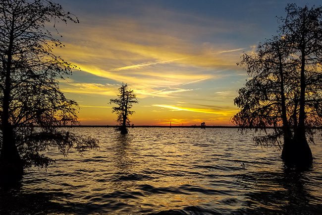
Lake Marion Santee Sunset

Austin Riley of Batesburg-Leesville, 2019 © Do Not Use Without Written Consent

The Village Round is a community building available for group gatherings such as reunions, meetings, and retreats. The facility boasts a large screened-in portion for grilling.

Santee State Park

Jim Dollar of Indian Land, 2014 © Do Not Use Without Written Consent

Below is a view of a small, unnamed lake within the park. It abuts a picnic area and campground but was closed several years ago due to a high population of alligators who call the lake home. The park provides both camp sites and cabins for overnight visitors. Camp sites are available for both primitive and RV camping with water and electrical hookup. Several of the campsites are lakefront.

Santee State Park Lake

Jim Dollar of Indian Land, 2014 © Do Not Use Without Written Consent

For those desiring more modern amenities, 30 cabins offer comfortable overnight accommodations; ten of the cabins are actually situated on the lake itself, resting on a pier. These cabins, pictured below, are sometimes referred to as “roundhouses” for their round appearances.

Santee Park Cabins

Jim Dollar of Indian Land, 2014 © Do Not Use Without Written Consent

Other natural features include the prevalence of cypress trees (Taxodium distichum) growing from the lake itself. The lake was a project of President Roosevelt’s New Deal, and much of the park’s surrounding land is cypress swamp. When land was being cleared for the lake in the early 1940s, the federal employees working on the project were called to serve in World War II. As a result, the lake was filled despite the remaining trees and stumps. Subsequently, wildlife viewing opportunities abound from both the lake and the park.

Santee State Park Rental Cabin

David McNamara of Columbia, 2019 © Do Not Use Without Written Consent

Another natural characteristic of the park is the presence of limestone sinkholes, or places where limestone has given way to time and erosion. Ecological communities form within these sinkholes, some of which are now ponds, as seen above, and others that are simply depressions. The sinkholes provide habitat to a variety of flora and fauna, depending on factors such as their depth and the presence or absence of water. The sinkholes within Santee State Park have been designated a Heritage Trust Site by the South Carolina Department of Natural Resources.

Fishing at Santee State Park

Jim Dollar of Indian Land, 2014 © Do Not Use Without Written Consent

Plan Your Trip: Santee State Park

Where is Santee State Park located?
Address: 251 State Park Road, Santee, SC 29142
GPS Coordinates: 33.521035,-80.501210
What else should I see?
Lone Star Barbecue 3 miles
Lake Marion 3.4 miles
Santee Wildlife Refuge 6.2 miles
Santee Indian Mound 6.2 miles
Show me more like this!
  • See other South Carolina Forests and Nature Preserves
  • Lake Marion Historic Sites
  • See other South Carolina Parks
  • Santee Historic Sites
$ 20.00
Select Payment Method
Personal Info

Credit Card Info
This is a secure SSL encrypted payment.

Donation Total: $20.00

    Santee State Park Map

    Please Help Us Stay Online

    We’d like thank everyone who generously supports the South Carolina Picture Project. You provide us with the inspiration and financial support we need to keep doing what we do. Every reader’s contribution, larger or small, is valuable. If you have enjoyed this website or found it helpful, please pitch in. Each donation helps – and it only takes a minute. Thank you!

    $ 20.00
    Select Payment Method
    Personal Info

    Credit Card Info
    This is a secure SSL encrypted payment.

    Donation Total: $20.00

    Reader Interactions

    Leave a Reply Cancel reply

    Your email address will not be published. Required fields are marked *

    Footer

    ABOUT US

    We are a federally-recognized 501(c)(3) nonprofit that works to preserve the history of South Carolina’s historic, natural, and cultural landmarks before they are lost to time. This website serves as a permanent digital archive of over 2,300 South Carolina landmarks – and counting. Learn more about our work.

    CONTACT US

    We’d love to hear from you! Send us a quick email at scpictureproject@sciway.net.

    If you are looking for permission to use a photo, please reach out directly to the photographer listed in the image’s credit.

    JOIN US ON FACEBOOK

    The South Carolina Picture Project has two Facebook groups. One is dedicated to SC Historic Landmarks and Iconic Landscapes, and the other is dedicated to SC Nature and Wildlife.

    South Carolina Picture Project © 2026 · All Rights Reserved